Uncategorized

Gardner Cave: A Walk Through Time

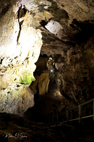
Gardner Cave is about as far north as you can get in Washington before going into Canada.  Low and behold there is even a hiking trail leading to the 49th parallel, and the trail takes roughly 30-40 minutes to hike both ways.  It’s a fun little side expedition while waiting for one of the guided cave tours to start.  These are the two highlight activities available in Crawford State Park, which in itself seems like a pretty average place at first glance.  Designated as a day use park Crawford does not offer camping, however campsites are available about a mile a way at Boundary Dam.  The only fees associated are the fact that visitors will need a Discover Pass as is standard for Washington State Parks.  The cave is the most common reason visitors come to see the area though, and that is for good reason.

The cave itself was first discovered by Ed Gardner while he was riding his horse.  As the tale is told Gardner’s horse stumbled into a soft spot that he would eventually discover to be the cave.  Some sources say it was found as early as 1899, but other accounts credit Gardner’s find around 1903.  The very early history of the cave is not very well known, although most agree it was used to hide Gardner’s bootlegging business.  He would later lose his land to William Crawford during a game of poker as legend has it.  Crawford would in turn donate the land to become part of the Washington State Parks system.  Holly Weiler explains that in the 1930’s the Civilian Conservation Corps installed some picnic areas.  Her publication on Out There Outdoors also shares that the cave was not updated for tourism until the 1950’s while the most recent installations happened in 1977.

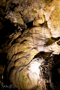
The geologic history spans a much greater timeline however,  and some sources such as this report on the Washington Trails Association website date the cave at 500 million years old.  Dated that far back, the site was actually an ocean floor at the time.  The process of decomposition in the shells of sea creatures eventually produced a sort of slime that would harden into limestone through time.  As tectonic plates shifted and moved, the were times when the limestone would also shift creating gaps and cracks.  This would allow the moisture to run through the surface and down to create geologic formations.  Being the 3rd longest limestone cave in Washington, Gardner Cave has a plethora of formations.  These geologic structures as explained by Washington State Parks include stalactites, stalagmites, with some rimstone pools, and flowstone.  Gardner Cave is also home to one of the most impressive columns in the region, and researchers estimate it to weigh nearly 8 tons.  A column is formed when a stalactite meets a stalagmite, and spans from the cave floor to the ceiling.  The tour guides explain these processes and much more during the actual tour, and for me it was a very educational and valuable experience.

The place isn’t too tough to find, and driving directions from Spokane, Washington are pretty straightforward.

Follow U.S. Highway 2 North, then turn left on State Route 211 toward Usk.  Reaching highway 20 head north along the Pend O’Reille River.  Upon reaching Tiger, take SR 31 toward Metaline.  Keep an eye out for Boundary Road in Metaline and take a left turning uphill.  Simply follow the signs from there.  Google maps will also lead right to it for those with access to GPS via cell phone.

Thanks for reading!

Uncategorized

Lake Lenore Caves

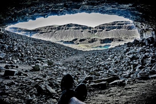
Located in central Washington, the Lake Lenore Caves are a nice place to relax and catch some awesome views.  Hiking up the path from the parking lot, the trails are well defined and easy to follow.  Concrete stairs lead to the top of a section of basalt, and the trails splits at that point.  The easier terrain to navigate leads to the right, while also offering a more direct route to the caves.  The caves are very easy to find, as the trail leads right to them.  They are not extremely expansive by any means, but the caves are large enough for a group to sit and eat lunch or find a cool spot to rest for a bit.  Some more challenging landscapes are off to the left, and hikers should lead with caution when walking that path.  From what I understand, there are signs posted at points to show some dangerous areas that are not recommended for hiking.  Another thing hikers should keep in mind is to be on the lookout for rattlesnakes, as pointed out by the Washington Trails Association.


Geologically this area was formed during the last ice age, during a time of immense flooding.  Torrential waters raced through the area, and ripped away chunks of basalt creating many of the ravines that can be found in Washington state.  Since then, the natural process of water getting into crevices in the basalt then repeatedly freezing and warming have hollowed out the caves.  The caves also bear a bit of a social history also, as natives were known to utilize them close to 5,000 years ago.  It is thought the caves were seasonal shelters, in which some of the natives would live and work there gathering plants, fish, and other supplies.  Spring and Summer would have been the most active, but as the seasons changed the natives would return to the permanent villages.  As mentioned on the website Only in Your State, some of the native petroglyphs can still be found along the walls.


Standing on the ridgeline, visitors can catch great views of Lake Lenore below which has a bit of an interesting story as well.  As explained by Heather Carr on Insteading.com the lake was once thought to be uninhabitable.  It was thought the geology of the area created an alkaline ph in the water that wouldn’t support life, so the military actually used it for a dumping ground at one point in time.  In 1947 the War Assets Administration had to dispose of 10 tons of metallic sodium, and they couldn’t find anyone willing to risk transporting it.  So the decision was made to drop the stuff into Lake Lenore, because the reaction would destroy the sodium.  Once the metallic sodium reacted with water, it would explode and release sodium hydroxide, hydrogen gas, and a lot of heat.

Here is a link to a YouTube video showing the disposal:  The Disposal of Sodium, 1947


Thanks for viewing, please like, leave a comment and share with friends.  Don’t forget to hit that subscribe button!

Uncategorized

Hiking Around Hawk Creek Falls

The area around and including Hawk Creek Campground is an interesting area, and that is because of the geological landmarks, the history of the land, and because of the recreation activities available to visitors.  The water level will vary depending on when a person visits, but the waterfall itself was flowing strong during both of my visits.  Mid January of 2018 provided a nice serene snow covered landscape, which was complimented by the sound of Hawk Creek cascading over the ledge and plunging to the rocks below.  Hiking the area at that time proved pretty difficult, but the campground was easy enough to navigate.  Navigating to the campground is easy enough with good directions, and the most accurate coordinates I could find are 47.816 N, 118.325 W according to Google Maps.

The wildlife in the area is probably what most folks would expect to see.  Deer, beavers, and probably the occasional elk or moose can be found wandering across the hills.  Waterfowl are typically floating around while birds of prey such as eagles dominate the skies.  Along with watching wildlife people can find quite a few activities to pass the time, such as biking, hiking, boating, kayaking, fishing, and swimming in the designated areas.

A couple things to consider when planning a visit are road conditions and the water level.  Most hikers seem to agree that the area is best to hike when the water is low, because you can follow a fisherman’s trail through the pines, around a couple bends, and down to the beach for a nice stroll.  As the water level increases through the year, beach access decreases.  If you happen to hike during the later part of the year, there are always some trails that lead up the hills to the rocky ridge line.  Along that ridge is where some caves can be found, although I am not sure exactly how many are up there.  Some great information about the 4.5-5 mile hike and the geology of the area can be found on this Washington Trails Association info page.

I happened to spot a massive cave from the parking area near the boat ramp, but visitors need to turn and look up the hillside through some trees.  The hike from there is not a super long hike, and there are a few game trails to follow.  However, the trek is a relatively steep grade, and there are some loose rocks along the path.  Once hikers reach the cave the view is pretty spectacular.

People can keep trekking along the ridge for an amazing view, and at certain times folks might be able to even make it out to the Columbia.  About 5 to 6 miles north is the confluence of the Spokane and Columbia Rivers, which is an area people may be able to visit in the same day if planned accordingly.  Planning also means packing appropriately, and this Outbound Collective report by Rose Freeman reminds people to pack all of the essentials with some extra food and water.  Plus the hiking needs will include comfortable and sturdy boots or shoes, some trekking poles, and of course a camera to capture some of the marvelous landscapes around.  It is also a good idea to take some camping gear if using one of the 21 provided camping spots.  Just remember to pay the small fee at the station.  All of those things considered, it should make for a great day trip for anyone wanting to visit the area.