Uncategorized

The Beauty & Power of Palouse Falls

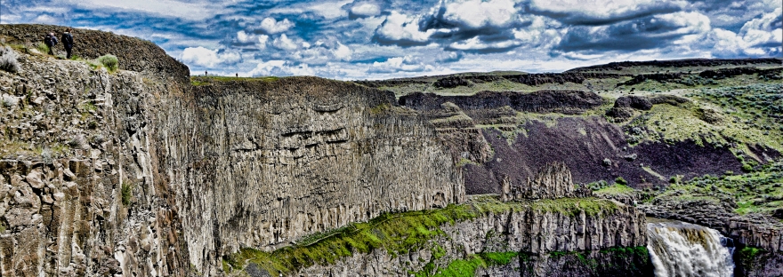
If you are thinking of travel in the Pacific Northwest or in Washington specifically, then Palouse Falls has got to be on your bucket list.  This powerhouse of a waterfall is incredible when the water levels are high, although it is quite majestic throughout the entire year.  The tremendous landscapes draw in large numbers of people, and on March 18, 2014 it was officially made Washington’s state waterfall according to the Washington State Parks website.

Photographers and artists alike make every effort to capture vibrant sunrises and captivating sunsets.  Palouse Falls does have a specific area with designated paths for walking, however there are a plethora of paths that lead to a multitude of incredible viewpoints, including the very edge of the waterfall looking down.


Warning signs are in place, because there is a pretty good risk of falling if hikers are not careful.  I went on several of the trails outside of the state park area, and found it to be quite an adventure although I recommend staying in the designated area unless well prepared.  One of the trails off by the railroad tracks had an old rope tied around a large bush and I was able to utilize that rope to rappel down the incline and reach the trails below.  That rope would serve as my only way back up the hill as well, making this trip more of an adventure than I had initially thought it would be.  This point is where I had my first interaction with some local wildlife, as I happened to spot a solitary yellow bellied marmot at the top of the hill, and another dozen or so down tucked into the rocky hillside below.  Other animals that visitors can possibly encounter are different birds of prey such as Peregrine Falcons, Golden Eagles, and Swainson’s Hawks.  These birds of course can occasionally be seen perched along the basalt cliffs or flying around scouting an area for possible food.  In the springtime, tourists to the area can expect to see some nice wildflowers growing as well.


The waterfall has quite an extensive history, both geologically and culturally.  According to many sources there is a tale once told by people of the Palouse Tribe, the Palouse river and waterfall were the scene of an epic battle between 4 giant brothers and a mythical creature called “Big Beaver.”  Story has it the brothers chased and attacked the creature 5 times, and each time they struck “Big Beaver” with a spear it caused a bend in the river.  The creature fought fiercely and valiantly during the fifth attack from the brothers.  The struggle tore out an enormous canyon, and this is where the river fell over the ledge and became Palouse Falls.  The canyon walls are said to show the jagged edges from “Big Beaver’s” claw marks.  Also, as mentioned on www.stateparks.com the waterfall was once called “Aputapat” meaning “falling water” or something close to that, but was later changed to honor the Palouse culture.

Geologically the canyon’s creation goes back around 13,000 years to a time of Ice Age Flooding and glacial movement, leaving Palouse Falls as one of the few remaining active waterfalls along this ancient glacial flood path.  The floods of that time were said to be extremely violent and catastrophic.  The park has plenty of information signs and a kiosk available for people to learn a bit about the floods.  These Ice Age floods left a destructive path as the ice, water, and mud ripped tons of rock and earth away to carve the canyons in parts of eastern Washington and the Columbia River Gorge on the way to the ocean at speeds possibly reaching close to 60 mph.  The state park here is also one of the more active camping areas in the region, so some pre-planning is almost essential if you want to make it in during low traffic times.


Campsites are available, and a lot of good information can be found by once again going to www.stateparks.com for price listings and regulations specific to Palouse Falls State Park.  A quick rundown shows that standard sites run $15, while utility sites are a bit more at $21.  Visitors can also expect to pay dump fees when using the dump station.  Campsites allow up to 8 people per site, and second vehicles can remain parked for an additional $10 per night.  Campers are allowed up to 10 consecutive days during the busy season, and they stay is extended to 20 days between October 1st and the end of March.  A Washington State Discover Pass is also required, or visitors will have to pay the park entrance fee of $10 for the day also.  Anyone visiting the park and waterfall will certainly be in awe of the massively majestic landscapes, and the crushing current that cascades nearly 200 feet into the canyon below.  Just remember to stay happy and stay safe when visiting!

Here are a few clips from my hike through the area:

Please comment, share, and subscribe!

Uncategorized

Hiking Around Hawk Creek Falls

The area around and including Hawk Creek Campground is an interesting area, and that is because of the geological landmarks, the history of the land, and because of the recreation activities available to visitors.  The water level will vary depending on when a person visits, but the waterfall itself was flowing strong during both of my visits.  Mid January of 2018 provided a nice serene snow covered landscape, which was complimented by the sound of Hawk Creek cascading over the ledge and plunging to the rocks below.  Hiking the area at that time proved pretty difficult, but the campground was easy enough to navigate.  Navigating to the campground is easy enough with good directions, and the most accurate coordinates I could find are 47.816 N, 118.325 W according to Google Maps.

The wildlife in the area is probably what most folks would expect to see.  Deer, beavers, and probably the occasional elk or moose can be found wandering across the hills.  Waterfowl are typically floating around while birds of prey such as eagles dominate the skies.  Along with watching wildlife people can find quite a few activities to pass the time, such as biking, hiking, boating, kayaking, fishing, and swimming in the designated areas.

A couple things to consider when planning a visit are road conditions and the water level.  Most hikers seem to agree that the area is best to hike when the water is low, because you can follow a fisherman’s trail through the pines, around a couple bends, and down to the beach for a nice stroll.  As the water level increases through the year, beach access decreases.  If you happen to hike during the later part of the year, there are always some trails that lead up the hills to the rocky ridge line.  Along that ridge is where some caves can be found, although I am not sure exactly how many are up there.  Some great information about the 4.5-5 mile hike and the geology of the area can be found on this Washington Trails Association info page.

I happened to spot a massive cave from the parking area near the boat ramp, but visitors need to turn and look up the hillside through some trees.  The hike from there is not a super long hike, and there are a few game trails to follow.  However, the trek is a relatively steep grade, and there are some loose rocks along the path.  Once hikers reach the cave the view is pretty spectacular.

People can keep trekking along the ridge for an amazing view, and at certain times folks might be able to even make it out to the Columbia.  About 5 to 6 miles north is the confluence of the Spokane and Columbia Rivers, which is an area people may be able to visit in the same day if planned accordingly.  Planning also means packing appropriately, and this Outbound Collective report by Rose Freeman reminds people to pack all of the essentials with some extra food and water.  Plus the hiking needs will include comfortable and sturdy boots or shoes, some trekking poles, and of course a camera to capture some of the marvelous landscapes around.  It is also a good idea to take some camping gear if using one of the 21 provided camping spots.  Just remember to pay the small fee at the station.  All of those things considered, it should make for a great day trip for anyone wanting to visit the area.

Uncategorized

Finding the Magic of Mystic Falls

Having visited the falls 3 times so far, I can honestly say I have enjoyed each trip down there.  Although it was during the colder Winter months the place was exquisitely beautiful, and had that layer of pillowed silence that the cold and snow seems to bring.  Mystic Falls can be found by hiking through Trail 121 of Indian Canyon Park.  This trail is known as the waterfall loop for obvious reasons, but it isn’t actually a true loop.  Adding a bit of trail 102 will effectively give hikers a looping trail to follow down through the ravine, to the falls, and back out as described in the Hiking Project.

Some hikers are volunteering to help repair or improve many of the existing trails, and that is because the falls could be considered a sort of forgotten gem.  The area itself is known to have a bit of a history also, as the last homestead of Spokane Garry can be found there.  I don’t personally know much about that, although I understand it is a tale filled with struggle and heartache.  There is a sign along one of the major trails that describes some major events in the life of Spokane Garry, and anyone visiting the park may find the story of interest.  Spokane Historical tells of the native history in more detail, and also explains how Indian Canyon is very near Palisades Park geographically.  Tracy Rebstock explains, “The Indian Canyon Park is one park in the Palisades Park area with 155.70 acres with a waterfall, vegetation, basalt rock outcrops and trails for both hikers and horses.”

Simply looking back on my own visits, I would say this is a must visit place for anyone in or near Spokane.  It may end up becoming a favorite place to visit, as it is quickly becoming a favorite of mine.  My first visit was a solo hike and took place in late December.  The entire waterfall was basically frozen solid, and it was actually my first time seeing a winterized waterfall.  I visited again about 3 weeks later with a buddy and fellow photographer Nate.  This time it wasn’t quite as cold, and the falls were flowing quite freely.  My last visit was only a few days ago with my wife Sarah, and the trails were once again snow packed.  After a brisk and brief hike, we made it down to see a half frozen waterfall.  The falls were basically outlined in ice with water flowing directly down a channel in the center.  Each visit presented unique opportunities to see this place and every time it was outright mind-blowing.  As you venture down the trail, you almost feel as if it is a bit of a fantasy world.  Trees reach out over pathways and the small creek babbles away.  This all leads up to the opening that brings hikers right up to the foot of the waterfall.  Give this place a visit or three, because I don’t think you’ll be disappointed.

Here is a brief video about Mystic Falls


Resources Cited:

Tracy L. Rebstock, “Indian Canyon Park,” Spokane Historical, accessed March 1, 2018, http://www.spokanehistorical.org/items/show/147.

Link to Creative Commons Licensing

Uncategorized

Frozen Falls, and That’s not All

Adventuring in the Pacific Northwest is pretty easy with all of the incredible landscapes in the region.  Sometimes it can be overwhelming trying to choose where to go or what to do, simply because there are so many options when considering the great outdoors.  Well, one area I would highly recommend would be the area surrounding Banks Lake and Steamboat Rock State Park, but you will probably need to visit more than one time in order to see all of the wonders this place has to offer.  The time of year in which you visit is also a major factor, because this place has several waterfalls that are only active from February into early and mid Spring.  My daughter and I visited the area on February 25, 2018 and we had an amazing time exploring, learning, and viewing the sites.

The two obvious natural settings that people should take in are of course the lake itself, which stretches 27 miles, and is home to a variety of fish.  Species include, but are not limited to, smallmouth and largemouth bass, rainbow trout, yellow perch, kokanee, walleye, and more.  This makes it an ideal spot for birds of prey to hunt for fish, and then return to the towering cliffs that run along the lake.


The  Washington Department of Fish & Wildlife  describes Banks Lake as being “ringed with basalt cliffs and talus slopes” which are colossal as you stand beneath them to watch the waterfalls.  When the falls are frozen and ice chunks break off, the thundering sound of ice smashing against ice is deafening as it echoes off of the cliffs.

We can’t forget about Steamboat Rock when we are talking about the cliffs either, as it sits atop the largest peninsula that juts out into Banks Lake.  It rises an incredible 800 feet above the lake and is roughly 600 acres on the surface.  It also has an incredible amount of things to offer any park visitors and campers.


According to www.stateparks.com “Steamboat Rock is a long-established area landmark, first used by nomadic Native American tribes and then by early settlers. The military currently uses the area for aircraft flying training missions.”  The area history before people were there simply points to a lot of glacial activity and ice age floods that helped to create the landscape we see today.  During the warmer months, the camping amenities are top notch and sites are scattered throughout a handful of areas.  Washington State Parks is another great resource for anyone interested in learning about what the park has to offer, any camping fees and regulations, etc.  As with other state parks in Washington, the Discover Pass is required for vehicle day use, or you can pay the required daily fee at the park station.  Next, we can learn a bit more about the area waterfalls.

Here is a brief narrative of the area:

Most of the areas waterfalls are unofficially named, except for Martin Falls, which was frozen solid at the time of my most recent visit.  I was able to find Paynes Gulch Falls, Rusho Creek Falls, and several others during my short day trip there.  Here is a short narrated clip featuring a few bits of what the area has to offer, but keep in mind I went a bit early in the season and the waterfalls were pretty much frozen solid.

Although my daughter and I didn’t see it when we visited, Martin Falls is the only officially named waterfall in the area according to the World Waterfall Database.  We didn’t get to see it, because we may have been early in the season, as nearly all of the waterfalls were frozen or barely flowing.  In either regard, they were all still very majestic and can all be found by browsing through the database mentioned above.  Most of these waterfalls are dropping from a very high distance, varying from just over 100 feet to an enormous 504 feet.  All of these points being made, this area is a spectacular place to visit and I certainly hope to visit again in the near future.